

SUCCESS
"Success is not final; failure is not fatal; It is the courage to continue that counts"
- Winston S. Churchill
ABOUT ME
My name is John Joseph Wardlaw and I am from the lovely Caribbean One Happy Island of Aruba. I am young dynamic 3rd year student looking for internship opportunities to expand my knowledge in civil engineering. I am looking to work in transport planning as it is a special interest to me.


School Projects
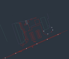
Project Landmeetkunde (Project Geodesy)
The assignment for this project was to perform measurements and plotting points to AutoCAD. The assignment had to be done in groups.
Each group had use a device for performing measurements and plotting points. The tachymeter was used in my group to execute the assignment. The assignment was carried out at a parking lot across the University of Curaçao.
The basis of the project was to carry out the following parts:
• The students must make a number of basic points (installation points) on site for the execution of the measurements.
• The students must use the GPS equipment to measure the terrain.
• With the help of the measured data, the students must make a drawing within AutoCAD as the final product of the measurements taken.


Project Infrastructuur (Project Infrastructure)
The assignment consists of two sides, the giving and the requested information.
The giving information is that the area is real area located at Hato airport and that the students had a topographic map scale 1: 1000 digital with indicated the location of the height lines of the teacher.
The requested information is that the students have to make a Program of Requirements (P.v.E.) for the development plan. Furthermore, the student must state the final plan of the development plan, together with the longitudinal and transverse profile of the road route.
The length profile of the road route must be drawn at height scale 1: 100 and the length scale at scale 1: 1000. Cross sections of the road route must be drawn to scale 1:50.
1. The plots must have a size of ± 2500 - 3000m2
2. The roads must be equipped with an elevated pavement
3. Drainage must be taken into account
4. The roads must be accessible to refuse trucks
5. Street lighting must be taken into account
6. The student must design parking options
7. The student must also take into account cables, pipes and planting
8. The student must take into account the further development of the area
9. The student should also take into account the decorating of the area


Project Draagconstructie (Project Supporting Structures)
The assignment for this project was to design and make a spaghetti bridge. The assignment had to be done in groups of two. We had to make three bridges in total.
The reason for this is that during the testing of the first bridge we have to determine where and why the bridge collapsed. Based on the analysis of the collapsed bridge we had make a new bridge by improving the weak spots.
After making the second bridge, we had to test the bridge again to determine where we have to make the bridge even stronger. This will be the last chance to strengthen the bridge, because the third bridge will be the final bridge.
The specifications for designing and making the bridge were the following:
- The first bridge should not weigh more than 250 grams;
- The second and third bridge may weight more, there is no limit on the second and third bridge;
- The heaviest possible load must be carried from the middle of the bridge;
- The bridge is supported on both sides by a horizontal section;
- The bridge support length must be 7 cm;
- Road surface with 7 cm;
- Beams may be made up of spaghetti, but may not have a larger diameter than 1 cm.


Project Openbare Ruimte (Project Public Spaces)
For the Project Public Space, there was an assignment that must be carried out by the students of architecture and civil engineering. The students had to develop an area. The area that had to be developed was the area between the Mega Piers and the Pater Euwensweg at Curaçao.
We had to make an attractive region to convince the tourists to go to Otrobanda (one side of town) instead of Punda (the other side of town).
Integration between the people and the functions of the region was very important. This meant that we had to come up with innovations for the design and architecture of the area.
This was possible by making an optimized and smooth traffic flow and a clear accessibility of the region.
GOAL:
The purpose of this assignment was to come up with ideas to make the location between the Mega Piers and the Pater Euwensweg more attractive. Why actually? When cruise ship tourists arrive on Curaçao, they are taken to customs. After this process the tourists go directly to the Renaissance Hotel, then Brion Plein (Brion Plaza) and then Punda.
The problem here is that the area of Pater Euwensweg does not look attractive / safe, so the tourists don't take this route. Another problem is that the tourist won't see the monuments, that is why we had to come up with ideas to not only make the area attractive, but also improve the safety of the are, lighting and infrastructure so that the tourists still opt for this route.


Projectweek for the Project Openbare Ruimte (Project Public Spaces)
For the project week of the Project Public Space, the second-year students of the faculty of technical sciences with the study of Architecture and Civil Engineering, together with students of the Universidad de San Buenaventura of Medellin Colombia, had to do a research for the possibilities of creating a connection between the Rif area and the heart of the Otrobanda district.
This was done by placing architectural interventions, to show that a small impulse can cause a change in mentality and ultimately enable a major (area) change to take place.
The theme for the project was "Nos ta Otrobanda Otrobanda ta nos" (We are Otrobanda and Otrobanda are us).
Three interventions were made: an infobooth, Otrobanda sign and possitive streets squotes to let people experience a good atmosphere around the area.


BIM Projects
The first assignment for the course BIM was to convert a 2D housing plan into a 3D model by using Archicad. The housing plan was for institutional company could FKP ( Fundashon Kas Popular)
The second assignment for the course BIM was to convert a 2D AutoCAD drawing of the University departments into a 3D model by using Archicad. The second assignment was a group project that had to be done in groups of maximum 3 students. The tasks was divided per group member. The tasks were architectural, constructor and electrician.


Work projects
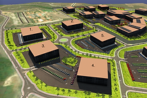
Residential development plan
While working at the architecture office O4IA of MSc. Raffy Kock, one of the many tasks that I had to do was to convert this 2D AutoCAD residential development plan into a 3D model in Autodesk Infraworks.
House floor plan
For this project I had convert the 2D AutoCAD drawing of the backyard of this house into a 3D model by using Sketchup


M.F.A. Dakota
For this project I had convert the 2D AutoCAD drawing of the frontyard of this multifunctional building into a 3D model by using Sketchup.

Frame grid 2

Floor and column layout

3D Model of the building without roofing
New commercial building 30 Wynde Boulevard
For this project I had convert the 2D AutoCAD drawing of the new commercial building at 30 Wynde Boulevard into a 3D model by using Autodesk Revit.
Firstly I had to do was to analyze the floor and column layout and then draw the floor and column layout into a 3D drawing in Autodesk Revit.
Secondly I had to analyze the beam, and column layout both for low and high positioning of the beam and columns of the buildings.
Thirdly I had to complete the 3D drawing of the building for the client.

Frame grid 3,4,5 and 6

First story beam and column layout (high)

First story beam and column layout (low)


Project House planning
For the project house planning, I had to finish the 3D Autodesk Revit model for the architect Raffy Kock.
The first task that had to be done was to complete the structure of the house. I had complete the foundation plan that includes the foundation piles and the pile caps for the foundation piles. I also had to complete the beam and column plan for the house.
The second task was the compete the roof framing plan and the roof plan.


Work Projects


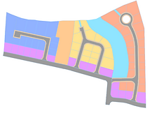
Area plan
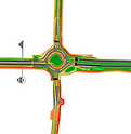
Project Watty Vos Boulevard (WVB)
For this project I had to convert the 2D AutoCAD drawing into a 3D model into Revit and afterwards import it as a 3D model in Autodesk Infraworks.


Watty Vos Boulevard

Project Retirement Home
For this retirement home project, I had to convert 2D drawings into a 3D model by using Autodesk Revit.
This project is intended to make a hotel for the elderly where they can receive daily care like the Eastbourne House Care Home at Whitley Bay at Newcastle Upon Tyne in England.
School excursions


Project location for the subject Project Openbare Ruimte (Project open Space), Pater Euwensweg, Curaçao, February 2, 2018


Project area of Otrobanda for the subject Project Openbare Ruimte (Project open Space), Sabasteeg, Curaçao, March 14, 2018


Second presentation and visitation HNO (New Hospital Otrobanda) given by architect, Curaçao, March 9, 2018


Presentation and visitation of project at Deventerstraat for the subject Landmeetkunde (Geodesy), Dienst Openbare Ruimte afdeling landmeetkunde, Curaçao, November 23, 2017


Presentation and visitation of tweede megapier (second mega pier of Curaçao), Curaçao, October 11, 2017


Presentation and visitation HNO (Hospital Nobo Otrobanda) given by architect Lyongo Juliana, Curaçao, March 24, 2017


Contact Me
De Savaan 214 G, Willemstad, Curaçao johnjosephw98@gmail.com| Tel: +59996751678